Southern Utah’s Backroads


Covering some 130,000 contiguous square miles of Utah, Colorado, Arizona, and New Mexico, the Colorado Plateau region is home to some of the West’s most dramatic rock formations and high desert landscapes. Uplifted millions of years ago by geologic forces, this eroded high plateau includes numerous national parks, national monuments and other federally protected lands of scenic splendor. Tourists, especially those riding motorcycles, flock here to witness the stunning sandstone rock formations in the region’s larger-than-life landscapes.
During warmer months, the most famous sites are swarming with tourists. However, there are less-traveled backroads, leading to stunning viewpoints, which are still largely bereft of selfie-snapping tourists. These are destinations that encourage quiet contemplation of Mother Nature’s million-year-old works of art. I will tell you how to find four of them.
This roundtrip of approximately 92 miles begins and ends in Bluff, UT. To reach most of the following four points of interest, riders will necessarily negotiate some gravel roads. Each of those roads, however, should be graded and relatively well maintained. Road conditions will usually allow most street-oriented motorcycles to have safe passage. I have even observed sport bikes bouncing through Valley of the Gods, albeit at a relatively modest pace. Of course, a dual sport or adventure bike would do it with less drama. During or immediately after rainfall, however, the gravel roads are usually not passable and you would be wise to give them time to dry.
The tour passes through remote high desert terrain with no services, including cell phone coverage, except possibly in Bluff and Mexican Hat, UT. Riders should pack extra water, snacks, a first aid kit, tools, maps, and any other items that might be needed. Before venturing out, make sure your bike and tires are in sound condition. This landscape is no place for a breakdown. And, of course, it’s always prudent to ride with a partner in remote areas.
Points of Interest

Valley of the Gods
A 17-mile-long gravel road winds through mesas, buttes, and towering cliffs of 250-million-year-old Cedar Mesa sandstone. Valley of the Gods, while similar to Monument Valley (but on a smaller scale), has the benefit of having no crowds, hiking restrictions, entry fees, required advance permits, or guides. This location does allow dispersed “leave no trace” camping, and it has a whole lot of blissful red rock solitude. Expect to spend at least one hour just riding through without stops.
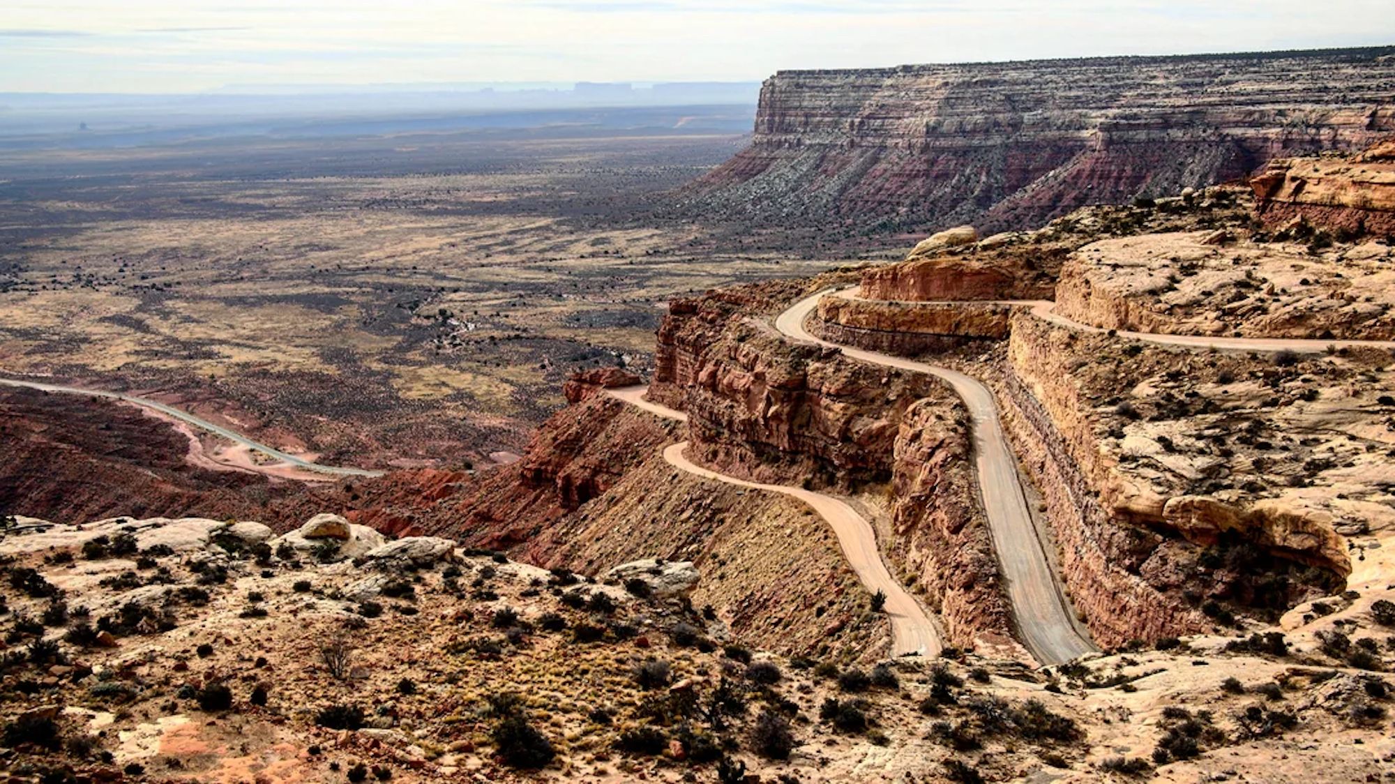
Moki Dugway
At only three miles long, this stretch of gravel switchbacks packs a lot of scenic grandeur into a short time. For example, one pullout presents a panoramic vista of the Valley of the Gods far below. This cliff-side byway also has expansive views of Utah’s Canyon Country. Although there are no guardrails (a mixed blessing for riders anyway), the steep grade, sharp drop-offs, eye-catching scenery, and hairpin curves suggest that motorcyclists ride it at a prudent pace.

Muley Point
After descending the Moki Dugway, follow CR 241 (aka Muley Point Rd, which may not have signage) to a triangular clifftop that overlooks Glen Canyon National Recreation Area, the gracefully entrenched meanders of the San Juan River, and the Navajo Nation, which is just beyond the river. The gravel road from SR 261 to Muley Point and back is approximately 16 miles.

Goosenecks State Park
Heading southeast on SR 261, make a right turn onto SR 316. In four miles of paved tarmac, you’ll arrive at one of the most iconic vistas on the Colorado Plateau. The San Juan River flows some 1,000 feet below this overlook, passing through two closely spaced meanders (or goosenecks), which were carved ever deeper over millions of years as the Colorado Plateau uplifted. Tiny specks of people in small boats are carried along in the river’s flow, which ultimately rendezvous with the Colorado River.