Skyline Drive, Virginia Shamrock Tour®

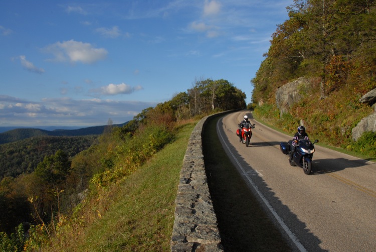
The Great Appalachian Valley is a gigantic trough that stretches 700 miles from Canada to Alabama. The eastern boundary, for most of its length, is the Blue Ridge Mountain Range. Skyline Drive threads its way along the top of these mountains in north central Virginia for 105 miles; it will be our home base for the next four days. I'm thrilled at the prospect of introducing my two world-traveling riding companions to the scenic wonders of this gorgeous slice of America.
Day 1: Journeying Into Jefferson Country
I suppose there’s an obvious reason why lyrics from the song “Raindrops Keep Falling on My Head” are cycling, nonstop, through my head. The temperature is in the low 60s, it’s raining, and fog as thick as pea soup is obscuring Skyline Drive’s famous scenic overlooks. Christa Neuhauser, riding the Honda VTX 1300, is visible in my rearview mirrors, but her son Florian, riding tail gunner on the Triumph GT 1300, is just a wispy shadow in the morning gloom. I’m itching to crank up the Ducati’s marvelous 150 hp motor, but that would be suicidal in these riding conditions.

At Skyline Drive’s southern terminus, the route plunges down to lower elevations, out of the murky mist. Although our lunchtime destination is only 20 miles east of here on I-64, our path takes a circuitous route further south along country lanes that rise, fall and twist over a tranquil rural landscape. The Ducati’s light, surefootedness inspires confidence on the still wet pavement. I twist the throttle of this steel pony and it surges ahead of the other steeds, like Secretariat racing down the home stretch to win the Triple Crown. Well, at least in my own mind.
Motorcycles & Gear
2010 Ducati Multistrada 1200s Touring
2010 Triumph Sprint GT 1300
2010 Honda VTX 1300
Helmet: Shoei X-Eleven
Jacket: Dainese Hilton Head GORE-TEX®
Pants: Vanson Leather
Boots: Oxtar Infinity
Gloves: Dainese
Charlottesville, VA is where our third president, and author of the Declaration of Independence, built his Monticello plantation, an architectural masterpiece that’s a UNESCO World Heritage Site.
Thomas Jefferson also planned the iconic buildings and innovative curriculum of another UNESCO World Heritage Site in Charlottesville: the University of Virginia. We break for lunch at a café just across University Avenue from the sprawling campus. And I reflect on the astonishing intellect and accomplishments of this Founding Father.
Riding two-lane tarmac back north, we enjoy the scenic splendor of Albemarle County. The rolling green pastures are dotted with magnificent thoroughbred horses, ensconced behind expansive rail fencing. This equestrian landscape extends west to the Blue Ridge Mountains, those distant geographic sentinels disappearing high up into the mist. With the expectation of a warm shower and a hot dinner awaiting us at the Big Meadow Lodge, we eagerly ascend the mountain ridge and are rapidly enveloped, once again, in Skyline Drive’s netherworld of furtive, pale images.

Day 2: Finding the Lost River
A brilliant azure sky greets our departure from Big Meadows on the second morning of the tour. With temperatures forecasted to be in the 70s and spirits on high, we can hardly wait to explore the tempting tarmac of this longest loop of the tour. The fun begins almost immediately when we descend the west slope of the Blue Ridge on US 211. I’m scraping the Honda’s pegs, trying, unsuccessfully, to keep up with Christa and Florian on their sportier mounts. They vigorously attack a succession of decreasing radius turns that have landed more than a few riders on their backsides.
We’re soon across the Shenandoah Valley and heading north into the wilds of West Virginia in the Lost River Valley. The Cacapon River flows into an underground channel here and becomes the Lost River. Although we, obviously, can’t see the river’s subterranean course, the towns of Lost City and Lost River, WV are a sure indication that it’s flowing surreptitiously beneath our very tires.

Although the river may be lost, we’re not, and so we arrive in Moorefield, WV at lunchtime. A hearty meal at O’Neill’s Restaurant restores our energy for the afternoon’s explorations. We ride south on WV CR-7, following a burbling brook through a narrow valley formed by Elkhorn and South Branch Mountains. It’s a relaxed ride through dense woodlands along a sinuous path of sun-dappled blacktop.
We stop for gas along US 33, where I talk to the attendant about the road’s tight, challenging path over the West Virginia/Virginia border atop Shenandoah Mountain. He advises that oncoming traffic often strays over the yellow line when drivers try to take the tight curves too fast. We’re careful to stay well to the right side of our lane as we enjoy the delicious curves this stretch of US 33 has to offer.
With the sun sinking low on the horizon, we make our way back to Big Meadow on Skyline Drive. The Shenandoah Valley overlooks are captivating with their views of a countryside that’s resplendent in the evening’s golden light. As the distant mountain ridges turn blue and then grey, in the fading light, a lonely hawk circles and swoops high above the valley floor.