The Dalles, Oregon Shamrock Tour®: Exploring the Columbia River Gorge Area

The Columbia River Gorge’s breathtaking vistas owe its heritage to a series of geological cataclysms during the last ice age. A huge 2,000-foot-deep glacial lake had formed over present day Missoula, MT. The ice dam, impounding the glacial melt, gave way, sending a massive torrent of destruction down the Columbia River. Geologists believe the ice dam may have formed, reformed, and collapsed more than 40 times, violently carving out the stunning basalt-lined gorge we see today.
Oregon Outback
I’ve been hoping for a return trip to this area ever since my last visit several years ago. Bruce Read, who has never laid eyes on the breathtaking vistas of the Columbia River Gorge landscape, is also excited to be here and can’t wait to roll out. We fire up the big Harleys and motor southeast from our home base in The Dalles, OR.
We’re gliding across a rolling topography that plays host to agriculture and cattle ranching. The desolate beauty seems more akin to Wyoming than the rain-saturated greenery usually associated with the Pacific Northwest. Off to the far right Mount Hood stands as a silent sentinel, which seems to be monitoring our progress across the great expanse. We’ve been told that the meteorological rule of thumb is that for every mile traveled east from Portland, one less inch of rain falls each year.

A left at SR 216 plunges us deep into the Deschutes River Gorge. A tightly coiled stretch of asphalt dives between steep canyon walls—it feels more like a barely controlled bobsled run. At the bottom, we arrive at Deschutes River State Recreation Area. Anglers line the banks of the rushing river, fishing for steelhead and trout. Native Americans are also there, fishing in their traditional way from a rustically constructed wooden platform near the foaming waters of Sherars Falls.
Farther down U.S. 197, we again descend into the naturally sculptured depths of Deschutes River Gorge to find Maupin, OR. This rustic little burg of around 400 souls is a favorite embarkation point for hikers, anglers, rafters, and hunters. We’re hoping to find premium fuel for our mounts, but the lone open service station pumps only regular, which could make our thirsty Harleys a bit disagreeable. We climb out of the gorge on a long switchback and pause at the top to appreciate the rugged scenery and Maupin nestled far below.
Arriving in the touristy ghost town of Shaniko, still looking for fuel, we have a decision to make. Continuing south on SR 218, which is our intended route, it’s highly likely that we could run out of gas before finding a suitable refill. While pondering the matter further, we dismount and explore this largely deserted Old West tourist stop. Virtually everything is closed for the season, except for the ice cream shop. As much as I like the frozen delight it’s no substitute for a too-long-delayed lunch. Decision made, we turn our ponies north on U.S. 97 and finally find sustenance at Lisa’s Country Cafe in Grass Valley. Our bikes, however, don’t get their even longer delayed refill until reaching Biggs.

High Times on Historic Highways
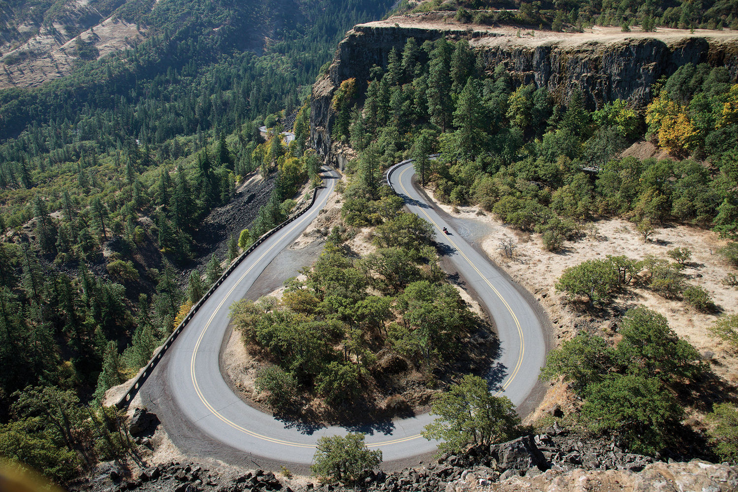
Heading west today into an area with a reputation for incessant rain, our second day couldn’t be nicer: low humidity, clear skies, and the thermometer registering in the 50s. Our first jaw-dropping panorama of the Columbia River Gorge occurs high atop Rowena Crest Viewpoint. The gorge’s immense scale, filled with the river’s sun-sparkled waters, is captivating. A tightly wound series of switchbacks, which led us up the sheer canyon wall, lie majestically far below our perch.
At Hood River, SR 35 leads south; in the far distance a magnificent giant punctures the sky with its glacier-caked peak. The geography and flora couldn’t be more different than yesterday’s terrain. Towering evergreens line the roadway as we wend our way through Mount Hood National Forest. Timberline Highway crawls up the inactive volcano to our lunch stop at historic Timberline Lodge. But still high above us, Mount Hood’s rocky peak rises more than 11,000 feet.
Motorcycles & Gear
2016 Harley-Davidson Electra GlideUltra Limited
2016 Harley-Davidson Street Glide
Helmets: Kabuto Ibuki, Arai RX-Q
Jackets: Joe Rocket leather, Dainese D-Dry
Pants: Vanson Leather, Dainese D-Dry
Boots: Oxtar Matrix 2 GORE-TEX
Gloves: Klim Element Short, Olympia GORE-TEX
After lunch we motor northwest, largely tracking the original route of Barlow Road, created in the 19th century. We finally exit onto the Historic Columbia River Highway, America’s first purpose-built scenic roadway, which took around 10 years to construct. The road’s path harmoniously blended cliff-face engineering with the gorge’s glorious natural aesthetics. No wonder at completion in 1922 it was dubbed “The King of Roads.”
Crown jewel of the King of Roads is the towering, massive chunk of solidified lava called Crown Point, which is capped off with an architectural treasure. Vista House is an exquisite octagonal two-story structure with an Alaskan marble interior. This over-the-top “rest stop” provides travelers breathtaking vistas of the Columbia River Gorge’s stunning tapestry of stone and water. The place is overflowing with visitors, including a number of folks traveling just like us on motorcycles.