
Text: Chris Myers • Photography: Chris Myers, Kathy Myers
Remember recess? It was every kid's refuge from the old three Rs. Fresh air and freedom reigned and rules were the exception. Unwinding was your sole responsibility and frolicsome fun ensued for no apparent reason. Most motorcyclists know how to get that feeling back and many of them head for the Western North Carolina Mountains to romp on the adult equivalents of those old childhood playgrounds.
The only bad part about recess was toughing out the last few minutes before the doors were flung open. The big hand's lethargic crawl only heightened the intensity of the teacher's eyes prowling the room, searching out furtive glances like a pair of spotlight beams in The Great Escape. Avoiding her piercing gaze just before the big breakout seemed as fruitless as squirming to dodge the bullets of a firing squad. All you could do was avoid eye contact, envy the kids that got to go outside a period earlier, and pray you wouldn't be the last one called upon to answer any math homework questions. And when that bell did ring, the simultaneous release of tension and energy gushed forth in a wave of relief that was almost palpable.
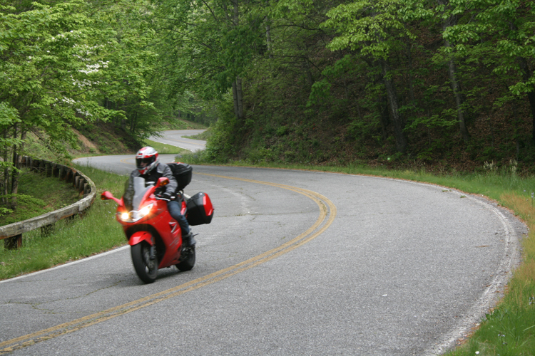
Funny how some things never change. In the last few days before Kathy and I were scheduled to leave for our Shamrock Tour in Bryson City, North Carolina, the clocks ticked slower, the easiest chores were studies in tedium, and more than once I cursed the people who had the foresight to schedule their trips a week earlier. Then finally, after rabid bouts of intensive doodling, Internet noodling, and prolonged fits of grumbling and gnashing of teeth, the bell finally rings - and the calendar sets us free to speed west from Winston-Salem on the nimble Triumph Sprint ST, giddy with the excitement of having four days of moto-playtime.
The Skyway: A+
Our first day dawns a little chilly and a lot foggy. But having once lived an hour east of here in Asheville, we know this is a temporary situation and not the least bit uncommon in early May. We breakfast in the Fryemont Inn's restaurant and wait it out with an extra cup of coffee on our cabin's private balcony. By 9:00, pats of blue emerge and expand as the fog burns off and the Sprint's eager triple quickly barks to life. Within minutes we're motoring southwest on Route 19-74. By the time we reach the Nantahala Gorge, the blanket of haze has melted away, exposing a brilliant sky. We ride into the valley's dense tunnel of hardwoods, where the sunlight spilling through the thick boughs mottles the narrow two-lane road and shimmers off the roiling Nantahala River. This tributary is nationally recognized as one of the finest whitewater rafting areas in the United States. Numerous outfitters along the way offer adventure-soakers ample opportunity to grab a paddle and get a frosty mountain dousing. But from our point of view, even though the midmorning sun is hard at work, the cool temperatures are much more conducive to running asphalt rapids.
As 19-74 leaves the gorge, it turns into a divided highway. But with ample mountain scenery, even the four lanes in these parts aren't that bad. Just past Murphy, we swing a right on to Route 294 and get back to the two lane. The ride is surprisingly relaxing until we cross into the Volunteer State and pick up Route 68. Though rather sedate looking on paper, this stretch of Tennessee tarmac pitches us into a deceiving blender of twists and scenery that challenge the chassis and our concentration. After braking way too late and nearly overcooking a hard right-hander, I get a slap to the side of my helmet. It's Kathy's way of telling me to either slow down and enjoy the views or to keep my focus as sharp as the pace merits. She knows it's dangerous for me to do both and isn't the least bit hesitant to keep me honest.
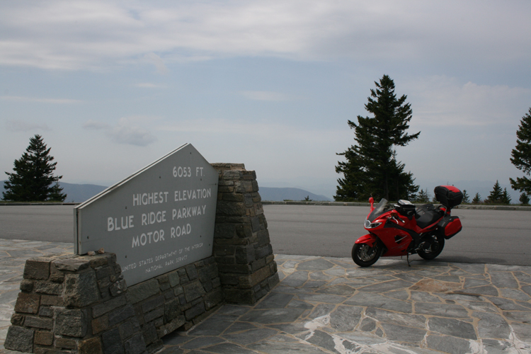
We ride into Tellico Plains in time for a late lunch and grab good sandwiches at the Town Square Café and Bakery. Knowing that the sun's rays are at their warmest this time of day, we decide not to dawdle as our next stretch of road, the Cherohala Skyway, packs an altitudinal punch and can be a little chilly in spots. Completed in 1996 after 34 years of construction, the Skyway now connects Tellico Plains and Robbinsville, North Carolina. Because it is built entirely on federal land through the Cherokee and Nantahala National Forests, the Cherohala's only distractions are its voluminous curves and spectacular views. The Sprint slings us across mountains that reach altitudes of 5,400 feet, treating us to grand panoramas around every corner. When here, keep in mind there are no services other than a few restrooms; so be sure to gas up, allow plenty of time, and keep the camera handy. Under no circumstances should a ride in this region preclude the Cherohala Skyway.
The Gap: A++
Our second day breaks much brighter and we both have java on the brain. During our stroll about town last evening, Kathy and I discovered Mountain Perks Espresso Bar and Café just across from the Great Smoky Mountain Railway depot. After downing cappuccinos, we don our armor, mount up, and head off in search of a Dragon. Peeling off of 19-74, we get a little warm-up on the sinuous Route 28 and then steer toward our meeting with that infamous section of Route one-two-nine.
Our first stop is the convenience store at the Deal's Gap Motorcycle Resort, strategically perched at the tip of the serpent's twisty tail. We never pass on opportunities to add another refrigerator magnet to our collection, and they have plenty. After exchanging pleasantries with some other riders and downing a bottle of water, we begin our hunt in earnest. Perhaps the most famous 11 miles of motorcycling bliss in the United States, the Tail of the Dragon is actually a section of Highway 129 hugging the southwestern tip of the Great Smoky Mountain National Park. This marvelously engineered ribbon of asphalt rockets riders side to side 318 times in those 11 miles, and the deep, shady forest that arches over the pavement gives the journey an oddly mystical quality. And the best part is there are no buildings, driveways, or cross streets to muck up the works. This being Kathy's first trip to the Gap, she's none too happy when we're slowed by a pickup and trailer combination. After my explanation that Route 129 is a public highway, open to all vehicles and not just sport-riding enthusiasts, she takes back most of her expletives and insists we go back and do it again before continuing on. Yes boss, no problem - which works out to 954 curves in 33 miles. Now that's an arithmetic lesson I can easily understand.
The Dragon is a mecca for riders and machines of all types from all over the country, and it's certainly worth the journey. Just remember, this is an extremely technical bit of road and can be dicey, especially on weekends when it's more crowded. Always exercise restraint and, by all means, ride your own ride.
Those three white-knuckled runs across the serpent's fiery spine have the adrenaline pumps working overtime. Timing is on our side though, as our next leg has us traversing a perfect decompression chamber, the Foothills Parkway. This stretch begins almost where the Dragon ends and weaves a gentle path through the western foothills of the Smokies. The sweeping bends and absence of traffic relax us and the views from the overlooks, especially those facing the Tennessee Valley to the west, are impressive. By the time we head back east on Route 321 for the return run to Bryson City, snacks, frosty beverages and the two rockers on the porch are utmost on our minds.
The Old Favorite: A+
Caffeine's hot and foamy siren song, along with cheddar-and-jalapeno bagels slathered in veggie spread, lure us back to the cafe. Fueled and stoked, we hit the road. In Cherokee, running the gauntlet of tacky, but fun souvenir stands overflowing with "genuine Native American crafts" never fails to amuse us. Try as we may, it's hard to picture the Cherokee Nation's elders handing down the ancient secrets of patiently crafting plastic snow-globes and pink, feathered key chains that look suspiciously like roach clips. But once we pass through the entrance to the Great Smoky Mountain National Park on Highway 441, the kitsch disappears and nature makes a grand reappearance. Deep, nearly impenetrable stands of oak, maple, and mountain laurel drape gurgling streams and splashing waterfalls. Deer graze nonchalantly at the far end of small clearings and road signs indicate that black bears are about. Reaching the breezy summit of the 5,448-foot Newfound Gap, we note that the trees have yet to sprout their summer leaves even though it's already May.
On the west side of the park, the Triumph noses toward a rendezvous with another section of Route 321. Rolling slowly through the tourist-choked town of Gatlinburg, Tennessee, we pick our way through a manmade valley of tall buildings strangled with neon lights, primary colors, and varieties of signage all designed to separate unwitting vacationers from their hard-earned greenbacks. Never have we seen so many pancake and steak houses duking it out for supremacy on the buffet battlefield. And judging by the depressing number of MTV fashion disasters waddling the sidewalks, business is good.
After a couple of thick, juicy burgers at Tucker's Main Street Cafe in Newport, we begin the return trip. The easy bends of Route 25 follow the French Broad River to the small town of Hot Springs just over the North Carolina border. This eclectic little crossroads is as popular a waypoint for hikers on the nearby Appalachian Trail as it is a rest stop for area motorcyclists and river runners. Having spent many an afternoon here years ago, we barely slow down making the familiar turn south on Route 209. This great, old byway hasn't lost a bit of charm, right down to its the notoriously gravel-strewn hairpins. Concentration can't lapse for a second here. The same precipitous drop-offs that offer stunning views of the deep valleys below can swallow bike and rider in the blink of an eye. Stay focused. From decreasing radii to wicked curves ringing sheer rock faces, the road flings one challenge after another. On pillion, Kathy is working just as hard as I am until the winding tarmac abruptly straightens out and offers a much-needed breather through Spring Creek. Then, as quickly as it started, the asphalt whirlpool sucks us in for another good thrashing across Betsy Gap before slowly winding down into Lake Junaluska. Yeah, there are many reasons why this road has always been at the top of the list.
The Parkway: A-
We awaken to another whitish sky, but this time real clouds and not morning fog obscure the blue. It's gotten significantly cooler too. When riding these hills, it's good policy to be prepared for any weather condition. We layer up and head toward Cherokee and the terminus of the Blue Ridge Parkway. Almost immediately the climb begins and the temperatures fall. Laden with numerous pullouts and boasting altitudes climbing to over 6,000 feet, this historic route offers countless views of the Appalachian Mountains' amazing sprawl. And just as we noted around Newfound Gap, many of the trees have yet to sprout their summer garb. At the higher vistas, it's neat to look out across the valleys and see the demarcation line between foliage and bare branches with the late-spring greenery creeping its way up the slopes. By the time we reach the Richland Balsam Overlook, the highest point on the Parkway at 6,047 feet, Kathy has about had it with the unseasonable chill. And honestly, I'm having a hard time disagreeing. With temperatures now in the 40s, we've achieved the point of true discomfort, despite our layers and liners. Many fabulous views are bypassed as we hunker down and make a beeline for Beech Gap and our ticket off the nippy Blue Ridge. We both heave a great sigh of relief when the sign for Route 215 comes into view.
Normally, this serpentine funfest is quite entertaining, but numb fingers and toes make it difficult to enjoy. After a few miles, the road's decreasing elevation plunges us into what feels like the tropics in comparison, although the mercury is only hovering in the mid-sixties. We stop in a sunny spot to shake off the cold, delighting in the tingle of feeling coming back into our fingers and toes. Times like this truly define the charming unpredictability of motorcycle travel.
Near Rosman, we bear right on Route 64. What should normally be a superb ride has recently fallen prey to more traffic than its glorious curves can handle. An influx of country clubs and luxury vacation developments has stretched the number of blue hairs, white Lincolns, and Florida tags completely out of proportion. The mild summer weather has attracted an unprecedented number of drivers who are incapable of handling the gentlest of mountain curves. No worries though, all along the way, thick groves of rhododendron encircle splashing streams, waterfalls, the small ponds, and tumble over mossy, weathered rock formations. Enjoy the scenery, it's wonderful; but give the cars plenty of leeway, they need it.
After another late lunch of barbecue and sweet tea at the Carolina Smokehouse in Cashiers, we shoot down Route 107 toward Cullowhee and Sylva. The cold morning and four days of intense riding have taken their toll, and we have no qualms about jumping on Route 441, the quick route back to Bryson City.
Oh well, recess is over - and though the bell is sending us back to class (work), we had a blast exorcising a winter of pent-up frustrations. For us, this was our first time out on the playground together after several months inside. OK, there's no grade for recess, but if there were, we started this year with a fat A scrawled across the calendar.
FACTS AND INFORMATIONTotal Mileage
Approximately 585 miles.In General
Over the years, the mountains of Western North Carolina and Eastern Tennessee have become a destination for motorcycle travelers of all stripes. Whether seeking spectacular views, tasty curves, or just a relaxing vacation, riders can find what they're looking for nestled in these hills. With the exception of dodging occasional, pesky rain showers, the summer weather is almost always good to great.How to Get There
Interstate 40 runs right through the tour area from the east and west, while Highways 19-74 and 441 are literally on Bryson City's doorstep. For those considering a flight to the area, Knoxville's McGhee Tyson Airport (TYS) and Asheville's Regional Airport (AVL) offer daily arrivals. Numerous motorcycle rental outfits operate throughout the region.Food & Lodging
The Great Smoky Mountains have been a major tourist destination for years. Small cafes and diners dot the region and nearly every chain is represented in the cities and towns. Sure, there's plenty of wide-open space here, but a good meal is seldom very far away.There are also plenty of accommodations. Inns, bed and breakfasts, hotels, and motels abound. For those who prefer nights under the stars, there are numerous motorcycle-specific and bike-friendly campgrounds. But do keep in mind that they fill up quickly during the summer, especially on the weekends.
Roads & Biking
The mountains surrounding Bryson City have some of, if not the best, motorcycle roads in the United States. The iconic rides are the Blue Ridge Parkway, Cherohala Skyway, and the Tail Of the Dragon; and countless lesser-known stretches of asphalt weave their way over and around these ancient hills. For the most part, the surface conditions are good to excellent and the scenery is nothing short of majestic. No matter what you ride, you'll find what you're looking for in the Smokies.Addresses & Phone Numbers
-Great Smoky Mountain National Park
(865) 436-1200
www.nps.gov/grsm/-Swain County Chamber of Commerce
800-867-9246
www.greatsmokies.com-Great Smoky Mountain Railroad
(800) 872-4681
www.gsmr.comBooks & Maps
-To route this trip, we used Garmin's Map source software. Though road location was spot-on, the type of road designation was less specific. In other words, we encountered dirt roads and had to re-route on the fly. Lesson learned. From now on, I'll pay closer attention to the "unpaved" icon on the AAA paper map's legend. The GPS is a great tool, but far from infallible.
-Two good titles for regional riding information are Hawk Hagebak's Motorcycle Adventures In Southern Appalachia (ISBN 1889596108 .95) and Dale Coyner's Motorcycle Journeys Through the Appalachians (ISBN 1884313485 $ 24.95).Motorcycle & Gear
2008 Triumph Sprint ST
Helmet: HJC FS-10
Jacket: Triumph Sympatex Pantha
Pants: Triumph Denim Jeans
Boots: Puma Desmo
Gloves: Triumph Hard CarbonThe Deal's Gap Motorcycle Resort
(800) 889-5550
www.dealsgap.comMost motorcyclists will agree that 318 curves in 11 miles sounds like a pretty impressive twist-to-straight ratio. It certainly is, and there's a stretch of Highway 129 on the Tennessee/North Carolina border that proves it. Known as the Tail Of the Dragon at Deal's Gap, this MotoGP-worthy piece of highway has been attracting motorcyclists and sports car enthusiasts for years. And nestled in a small cove at the junction of Highways 129 and 28, the official start/end point of the Dragon, the Deal's Gap Motorcycle Resort has been catering to the needs of tired, hungry, thirsty, and souvenir-starved Dragon slayers for years. More than just a gas stop and bathroom break, the resort offers a fully stocked convenience store, a grill dishing out every manner of short-order favorites, a 14-room motel, and even an area for tent camping. Unfortunately, no motor homes or trailers are allowed. The rates are reasonable, the facilities clean (relatively speaking, for always hosting a bunch of motorcyclists), and the staff is friendly. While you're there, be sure to pay homage to the Tree Of Shame, an interactive memorial to those who have experienced the misfortune of stepping on the serpent's tail. Because you never know who or what you'll see here, the Deal's Gap Motorcycle Resort ends up being almost as much fun as the road. No motorcycle trip to Western North Carolina or Eastern Tennessee is complete without a dash across the Dragon and a commemorative tee-shirt from this legendary stop.
Fryemont Inn
(800) 845-4879
www.fryemontinn.comKathy and I knew we would enjoy our stay at Bryson City's Freymont Inn before we pulled our helmets off. The tall hemlock trees surrounding the main building extend a shady peace that's comfortable and welcoming. The expansive, open lobby extends out onto a large rocking-chair porch overlooking the town of Bryson City and the surrounding Smoky Mountains. Built in 1923, the inn is on the National Register of Historic Places and offers guests a real slice of history to go along with their stay. Antiques and memorabilia highlighting the Freymont's past line the walls. The rooms in the main lodge are all uniquely furnished and none have phones or televisions. Internet you ask? You're on vacation; leave the computer at home. This is one inn that practices what it preaches on the peace-and-quiet front. But for those of you like us, who have to have some modicum of modernism, there are cottages available adjacent to the main building that are plugged into that newfangled cable-TV thing. Our suite was in a cozy rondette and had our favorite post-ride feature, a private deck with rocking chairs.
The Freymont Inn has a full-service bar and restaurant, and the room prices include breakfast and dinner. Downtown Bryson City is within easy walking distance, but the hike back can be a challenge. And for those who like a little dip to soak away the saddle stiffness, an inviting swimming pool awaits.
Kathy and I thoroughly enjoyed the privacy and quietude of our cottage-suite stay at the Freymont Inn. Owing to its ideal location in the middle of the best riding the Smokies have to offer, we wouldn't hesitate a second to call this lodge our "mountain home" again.
Bryson City, North Carolina
If you head to Bryson City looking for rollicking nightlife and a wild party scene, you'll be disappointed. But, if the idea of a small-town atmosphere, friendly folks, and having most everything within walking distance sounds appealing, this sleepy mountain town is A-Ok. Located at the doorstep of the Great Smoky Mountain National Park, Bryson City is accustomed to its fair share of tourists and welcomes visitors with open arms. A surprising number of restaurants, ranging from drive-ins to barbecue shacks to Italian and Mexican eateries, are scattered about town. A stroll along the quiet streets turns up several art galleries, bookstores, and gift shops. And if a day off the bike is on the agenda, the Great Smoky Mountain Railroad's scenic Nantahala Gorge Excursion departs from the train depot downtown. Other outdoor activities - including whitewater rafting, hiking, fishing, and mountain biking - are sponsored throughout the Swain County area. But of course, the best activity, great motorcycling, can be found in every direction from Bryson City. The Tail of the Dragon at Deal's Gap, the Cherohala Skyway, and the Blue Ridge Parkway are a mere stone's throw away. And if "destination" roadways aren't your things, just pick a direction and get lost. There really isn't a bad route in the area.
It's hard to top a motorcycle vacation in the Great Smoky Mountains, and Bryson City's central location is the perfect hub. Located just off of Highway 74, less than an hour west of Asheville, it's a sweet spot that's easy to find, and a great riding experience is guaranteed.