Shamrock Tour® - Palm Springs, California
I have a theory that most males are fascinated by either wheels or spheres. The latter group spends much of their recreational time chasing a ball or watching someone else do the same. The "true" wheel guys share a passion for transportation, and they couldn't care less about RBIs, touchdowns, dunks or golf. It's well known that Palm Springs and its satellite resorts are set up for those birdie chasers, but what's a wheel guy going to do there? Hit the road, of course!
Spit on the desert, they say, and something will grow. In the case of Palm Springs, the spit is the Coachella branch of the All-American Canal, bringing Colorado River water 159 miles from Imperial Dam near Yuma, Arizona. Though made famous in the 1930s as a Hollywood "colony," Palm Springs couldn't accommodate much growth until this steady flow of fresh water arrived in 1949. Now it hydrates and cleanses 300,000 people, keeps the golf courses exceedingly green, irrigates the palm plantations, and tops up the pool at my hotel, the Wyndham Palm Springs on Tarquitz Canyon Drive.
It's Sunday, and Cheryl and I have just ridden in from Phoenix, Arizona on a 2006 Electra Glide Classic from EagleRider Rentals. We find the Wyndham easily and settle into our delightful suite. It's been a long, dry day, and we're both ready for a beer. The Wyndham is close to downtown, so we set off on foot. The Blue Guitar supposedly presents some of the best jazz in town, but as we start climbing the stairs to its patio, we hear, "Sorry, we're just closing." At 6:30pm? A jazz bar??
Okay, so there's The Ale House right across the street, but just as we're taking a seat at the bar, a guy turns us around with another "Sorry!" I'm thinking, this is America - the land of 24-hour, drive-through everything? Had we wandered into a teetotaler's parallel universe? Fortunately, the Wyndham's Oasis pool bar is very much open, and we finally get to wet our road-parched throats.
Day 1: On the Anza Trail
Over breakfast the next morning, I sit programming my test Garmin Quest 2 GPS unit. I'm a GPS newbie, and therefore the best possible "Street Pilot test pilot." It doesn't take me long to understand the basics, but programming my route for the day takes me 10 minutes or so.
The GPS plugs into the Glide's accessory outlet, and I soon become familiar with the commanding tone of the recorded voice. "Turn right!" she demands as we approach the turnoff for Hwy 74 in Palm Desert. Her stentorian tones reminded me of a former British prime minister, so I named her "Maggie," after Mrs. Thatcher. Garmin's announcer has the same irrefutable manner, with no space in this version's digitized vocabulary for molly-coddling terms like 'please'.
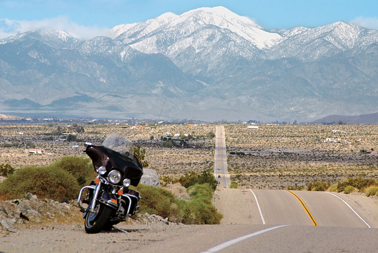
Right away, we're riding a whiplash road snaking across the mountain face between successions of hairpin turns. It's the kind of road that, if you lived here, you'd want to ride each day before breakfast. The Glide isn't the fastest bike, and I pull over to let a succession of Mercs, Saabs and BMWs go by - no one here drives a Chevy - until we reach a more spacious pullout for views near the crest. The tortuous tarmac is laid out below like a Google Earth view.
We continue climbing, spinning through the coarse alpine landscape of boulders and scrappy evergreens along the Juan Bautista de Anza Scenic Drive. In 1775 Bautista led a group of missionaries out of Mexico across the Sonoran Desert to the Pacific coast, establishing missions in Monterey and what is now San Francisco.
South on 391 through Aguanga, the road lined with orchards and rolling fields, we stop for gas in Warner Springs, where my credit card is declined. A quick call to Visa fixes the problem, but I'm told it's a good idea to inform your credit card company before you leave home!
About that time, Maggie stops talking to me. I had reprogrammed the directional dominatrix because she sent me into the Los Coyotes Indian Reservation - not where I wanted to go. Of course, any computer is only as good as the programmer...and now I have to reset the audio to coax her out of her sulks. We turn east on San Diego county road S2 for Borrego Springs. I round a bend revealing a jaw-dropping view across maybe 60 miles in which the road twists to the flat desert floor with the Salton Sea beyond.
We sweep down the winding blacktop into Borrego Springs and its broad, lazy Main Street, punctuated at its end with a wide traffic circle. I choose the third exit, and Maggie upbraids me. "Turn left!" she barks, telling me I've missed the viapoint, so I follow her instructions and end up in an industrial park. Hmmm...