California's Highway 1

It's July and I'm in Redding, California. I have to return my borrowed SV650S to American Suzuki in Los Angeles. I could strafe Interstate 5 through the Sacramento and San Joaquin Valleys under the blistering summer sun and get there in a day. Or I could add a day to my trip and savor the serpentine bends and ocean breezes of California's coast road, Highway 1. - Is there a choice?
"California One" was begun, not as I had assumed as one of FDR's New Deal projects, but by joining a piecemeal collection of existing coast roads, starting in 1919. The intention was to create a continuous coast highway from Mexico to Oregon. It's true that many of the intermittent stretches of highway were linked during the 1930s and '40s, but it wasn't until 1964 that the more-or-less continuous road from Leggett to San Juan Capistrano was finally accorded a single designation: Highway 1.

From Redding, though, I first have to get from the Sacramento Valley to the west coast. That means traversing the Siskiyou Mountains and the Shasta-Trinity National Forest, and reprising one of my favorite roads: California 36. The northern reaches of the Golden State are blessed with exquisite twisties, and those on 36 are some of the finest and most challenging. The tarmac inevitably tracks the meandering creeks, canyons and cliffsides through the Siskiyous, presenting an unsuspecting rider with blind decreasing radius turns as well as a sublime succession of fast sweepers. Especially enjoyable is the rollicking ride through the western slopes down to Rio Dell on Hwy 101.
Motorcycle & Gear
2006 Suzuki SV650S
Helmet: AGV Ti-tech
Jacket: Olympia
Pants: Draggin' Jeans
Boots: BMW Allround
Gloves: Rev'it
South on 101 takes me along the Avenue of the Giants. The towering trunks of the redwoods and their dense-needled branches create a cool microclimate of dark tunnels and glades. Big trees are a strong roadside theme: the "one log" house; the 24-ft diameter "grandfather tree" and, of course, drive-through trees by the dozen. I rode my bike through Leggett's "Chandelier Tree" on a previous visit in 2001, but decide to pass it this time.
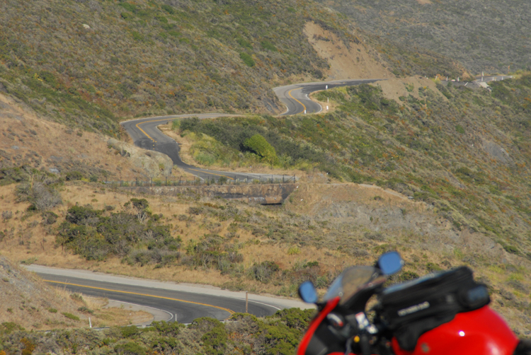
Leggett is the northern end of California 1. The 15 miles leading to the coast was the last section to be completed, in 1951. As a result, the 100 miles of California coastline north from Rockport to Ferndale became the longest stretch without a highway, earning its "Lost Coast" appellation. Between Leggett and Rockport there are some of the twistiest stretches of tarmac anywhere: the narrow blacktop, just a single lane in places, zigzags through the trees and leaps over the slopes like a startled deer. Straights for overtaking the crawling motorhomes and dawdling cars are scarce, but somehow I manage…
"I left my heart in San Francisco…"
One thrusts me out of the woods right onto cliffs overlooking the ocean. Under a clear azure sky, white-fringed waves roll ashore on a narrow beach. A cool ocean mist drifts inland, obscuring the view. At other times, I've traveled the California coast seeing almost nothing of the sea, and I'm hoping the mist will burn off on this trip. The road hurtles back into the redwoods for 20-odd miles, leaving the haze of the coast and treating me to a riotous romp of tight turns and sweet esses as it winds through the trees.
Back near the coast, the mist hangs over Mendocino's trendy town center of organic markets, galleries and bookstores. I had planned to stop for gas and some refreshment at the Stewarts Point General Store a few miles further south, but when I get there, the old wooden building on stilts is closed. Stewarts Point is also notable as the start of the Stewarts Point-Skaggs Springs Road, one of northern California's most famous and favorite motorcycling detours. Unfortunately, it's also a popular revenue-generating road for Sonoma County speed cops!

Staying on the coast, I roll south through Jenner and Bodega Bay (the setting of Hitchcock's The Birds) toward San Francisco. A magical stretch of road, the highway rambles over grassy cliffs and deeks around the edges of the numerous ravines and inlets that slice into them. I've attended two motorcycle-press intros that have used this stretch of highway, and it's featured in numerous on-screen car ads too.
It's also a popular weekend motor-tour route as I discover when Stinson Beach nears, with traffic becoming thicker than the bugs piling up on my windshield. The mist has dissipated though, and the sun is sinking low over the sea as I turn onto Conzelman Road, a route that takes me to a favorite overlook of the Golden Gate. Luck holds, and I'm rewarded with a bright, beautiful view of the world-famous bridge.
Next day, the morning fog is definitely chilling the air (just as Tony Bennett noted in his classic song) as I hand over my five dollars for the bridge toll. I'd planned to take One out through the city, but a washout on the coast near Pacifica put the kybosh to that. My consolation: riding riotous California 92 through the coast hills to Half Moon Bay, crossing Skyline Boulevard on the way. South of 92 near Woodside is Alice's Restaurant, and I would have loved to detour to meet the Sunday morning riders, but my schedule is too tight.